|
boundaries bounding surfaces
chronostratigraphy
lithofacies
lithology
lithostratigraphy
maximum flooding surface (mfs)
ravinement erosion surface
sequence
sequence stratigraphy
sequence boundary
stratigraphy
stratum
systems tract
transgressive surface
unconformity

|
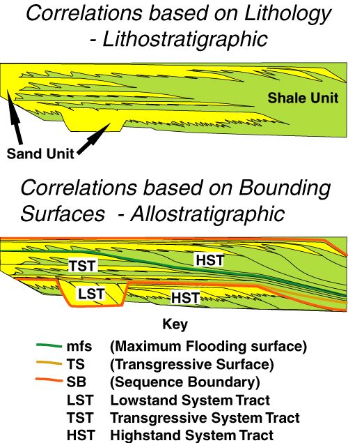
Sedimentary stratigraphy is concerned with interpreting, correlating and mapping sedimentary rocks. Lithostratigraphy maps these sedimentary rocks solely on the basis of their lithology and does not necessarily consider that these rocks may have accumulated over a particular period of time. In contrast allostratigraphy maps the rock units on the basis of the timing of their accumulation.
Thus the technique known as "lithostratigraphy" involves the interpretation, correlation, and mapping of sedimentary rocks on the basis of similarities in lithology and/or lithofacies. The practice of interpretation, correlation, and mapping based on "lithostratigraphy" often ignores significant breaks in the sedimentary section, including those caused by unconformities, omission surfaces, ravinement surfaces, and flooding surfaces. This can lead to significant mis-correlations, particularly if it is assumed that the "lithostratigraphic" units accumulated over the same interval of time.

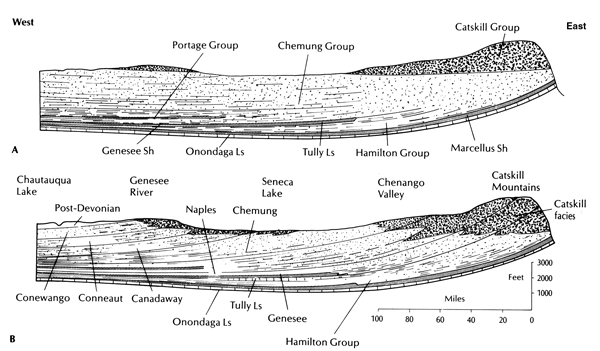
East-west cross sections across the Devonian Catskills sequences of southern New York showing the differences between "lithostratigraphy" and "allostratigraphy".
(A) Traditional lithostratigraphic interpretation (pre-1930), which treated the units a layer-cake sequence of Hamilton and Portage shales, Chemung sandstones, and Catskill redbeds.
(B) Present allostratigraphic interpretation, following Chadwick and Cooper that incorporates modern concepts of facies change. Time planes are shown by curved lines; each unit consists of Catskill redbeds in the east, sandy facies in the center, and shales in the west
(After Dunbar and Rodger, 1957; copied directly from Prothero and Schwab, 1996).
In contrast, the technique known as "allostratigraphy" involves stratigraphic interpretation, correlation, and mapping which uses discontinuities and surfaces to subdivide the sedimentary section. These discontinuities and surfaces are assumed to have time-stratigraphic significance (NACSN, 1983) and may include unconformities, omission surfaces, ravinement surfaces, and flooding surfaces (Bhattacharya and Walker, 1991a).
"Allomembers" are defined as representing lithologically heterogenous units that contain strata that may have previously been included in different formations. Thus "Allomember" boundaries cut across the conventional lithostratigraphic boundaries and better illustrate the genetic relationships between the different lithostratigraphic units (Bhattacharya, 1994). This can be seen on the movie that records the ClasticCycle and can be accessed by clicking on the image in the vertical menu to the left.
The "sequence stratigraphic" approach is a higher order of allostratigraphy that assumes a connection of the discontinuities and surfaces used to subdivide the sedimentary section to changes in base level. It also tends to give unconformities a higher level of significance, when subdividing the sedimentary section, than ravinement surfaces and/or flooding surfaces. Unconformities are used to bound packages of sedimentary rock and subdivide them into sequences. "sequence stratigraphy" involves the study of rock relationships within the chronostratigraphic framework of a sequence, which in turn is a cyclic succession of rocks composed of genetically related units of strata (Posamentier et al., 1988).

References
Bhattacharya, J.P., and H.W. Posamentier 1996, Sequence Stratigraphy and allostratigraphic Applications in the Alberta Foreland Basin, in Geological Atlas of the Western Canada Sedimentary Basin, Chapter 25, 96/11/29
J.P. Bhattacharya and H.W. Posamentier , 1994, sequence stratigraphy and allostratigraphic Applications in the Alberta Foreland basin. In Geological Atlas of the Western Canada Sedimentary basin. G.D. Mossop and I. Shetsen (comps.). On-line version: http://www.ags.gov.ab.ca/AGS_PUB/ATLAS_WWW/A_CH25/CH_25_F.HTM (1998,01,20)
Bhattacharya, J. and Walker, R.G. 1991, allostratigraphic subdivision of the Upper Cretaceous Dunvegan, Shaftesbury, and Kaskapau Formations in the subsurface of northwestern Alberta. Bulletin of Canadian Petroleum Geology, v. 39., p. 145-164.
Dunbar, Carl O., Rodgers, John, 1957, Principles of stratigraphy. John Wiley & Sons, New York, p356
North American Commission on Stratigraphic Nomenclature (NACSM), 1983, North American stratigraphic code, American Association of Petroleum Geologists, Bulletin, v. 67, p. 841-875.
Mossop, G.D. and Shetsen, I (compilers) 1994, Geological Atlas of the Western Canada Sedimentary basin. On-line version: ./././B.SHTML/AGS_PUB/ATLAS_WWW/ATLAS.HTM (1998,12,09), Alberta Geological Survey
Posamentier, H.W., Jervey, M.T. and Vail, P.R. 1988, eustatic controls on clastic deposition I - conceptual framework. In: Sea level Changes: An Integrated Approach. C.K. Wilgus, B.S. Hastings, C.G.St.C. Kendall, H.W. Posamentier, C.A. Ross, and J.C. Van Wagoner (eds.). Society of Economic Paleontologists and Mineralogists, Special Publication 42, p. 109-124.
Prothero, DR, and Schwab, F., 1996, Sedimentary geology: New York, WH Freeman and Company, 575 p.
|