Rinevilla Point
This locality exposes the upper Ross Formation as a series of amalgamated deepwater turbidite channels displayed in a wave-cut intertidal platform oblique to depositional strike.
This page introduces a gallery of photographs that illustrate the geology of the Ross Formation with outcrops along the northern shore of Shannon Estuary in Co. Clare at Rinevilla Point just west of the cliffs of Kilcredaun and the harbor at Carrigaholt, and east of the Rehy Cliffs.
Most of the photographs in this gallery were taken by Christopher Kendall on the SEPM Field trip there in 2008. David Piles kindly supplied a helicopter view of Rinevilla Point and Rehy Cliffs to the west. Most of the the cross sectional diagram and images are from the 2008 SEPM Field Guide and reflect the research of Morgan Sullivan. The gallery illustrates the character of the deepwater sediments of the Ross Formation and the turbidite sheet sands of the deepwater fan lobes of the Ross Formation with common shallow channeling.
Key Points Morgan Sullivan in the SEPM Guide book makes are:
-
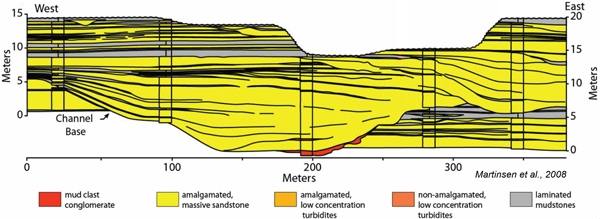
Dominating the Rinevilla Point outcrop are two laterally offset, and compensational stacked, channels with erosional bases.
-
Channels are less than 400 meters (1300 feet) wide and 10 to 15 meters (32 to 48 feet) thick with aspect ratios (width versus thickness) ranging from 20:1 to 40: 1.
-
Channel-fills are semi-amalgamated and with lateral degradation in reservoir quality. Fill is dominated by highly amalgamated massive to cross-bedded sandstones in an axial position that grade laterally into progressively thinner-bedded, less amalgamated massive sandstones toward the margins.
-
This difference in the lateral degree of amalgamation from axis to margin may suggest that the turbidity currents that deposited these sandstones were "underfit" relative to the channels (Sullivan et al., 2004).
-
They also display a distinct "upward thickening" and upward expansion (widening) architecture. This type of vertical and lateral organization of channel-fills has been interpreted to reflect the progressive loss of efficiency of the channel to transmit sediment down slope and the back-filling of the channel (Clark and Pickering, 1996; Beaubouef et aI., 2000).
-
Toward the east end of the outcrop, easterly dipping surfaces can be traced from the top of the channel to well within the channel where the surface is lost due to amalgamation. The surfaces are interpreted to be the product of lateral channel migration and suggest that there is some degree of sinuosity in the channels.
-
Net-to-gross ratios for individual measured sections vary from 70 to 95% with an average of approximately 90%.

Figure: proximal fan channels in Ross Formation dominated by highly amalgamated massive to cross-bedded sandstones in channel axis position flanked by progressively thinner bedded, less amalgamated massive sandstones toward margins. Note distinct inclined in east portion of channel. These inclined surfaces are product of channel margin migration of a sinuous channel (modified from Sullivan et al., 2000b, Sullivan et al., 2004).
Bibliography
Martinsen, O., Sullivan, M., Pulham, A., Haughton, P., Harper, H., and Elliot, T., 2008, Outcrops Revitalized: Tools, Techniques and Applications Kilkee, County Clare, Ireland, June 22-27, 2008, SEPM Field Guide, p1-58.
Pickering, K.T., Hiscott, R.N., Kenyon, N.G., Ricci Lucchi, F., and Smith, R.D.A., eds., 1995. Atlas of deep- water environments: Architectural style in turbidite systems, Chapman and Hall, London, 329 pp.
Pickering, Kevin, and Nicole Bayliss, 2006, "Mass-Transport Complexes (MTCs), and Tectonic Control on Confined basin-Floor Submarine Fans, Middle Eocene, South Spanish Pyrenees", SEPM Research Symposium: The Significance of Mass Transport Deposits in Deepwater Environments II, AAPG Annual Convention, April 9-12, 2006 Technical Program
Sullivan, M., G. Jensen, F. Goulding, D. Jennette, L. Foreman, and D. Stern, 2000, Architectural analysis of deep-water outcrops: implications for exploration and development of the Diana Subbasin, western Gulf of Mexico, in P. Weimer, R. M. Slatt, J. Coleman, N. C. Rossen, H. Nelson, A. H. Bouma, M. J. Styzen, and D. T. Lawrence, eds., Deep-water reservoirs of the world: Gulf Coast Section-SEPM Special Publication, p. 1010-1031.
Sullivan, M.D., Formeman, J.L., Jennette, D.C., Stern, D., Gerrick, N.J., Goulding, F.J., 2004, An integrated approach to characterization and modeling deep-water reservoirs, Diana Field, Western Gulf of Mexico, in Integration of outcrop and modern analogs in reservoir modeling: AAPG Memoir 80, p. 215-234.
Sullivan, Morgan D., Donald A. Medwedeff, Jim Borer, Hugo Ortner, Julian Clark, Douglas Paton, Bruce Trudgill, and Robert Amerman, 2006, “Effect of Active Structural Growth on Deep-Water Reservoir Architecture: An Example from the Cretaceous Upper Gosau Subgroup, Northern Calcareous Alps, Austria”, Recent Advances in Deepwater and Shelf Siliciclastic Facies Models: Implications for Reservoir Characterization (SEPM), AAPG Annual Convention, April 9-12, 2006 Technical Program