|
aggradation
aggradational parasequence set
boundaries bounding surfaces
marine flooding surface
parasequence set
progradation
progradational parasequence set
retrogradation
sequence
stacking patterns
systems tracts 
|
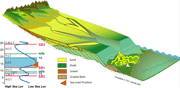
A shoreline or shelf margin trajectory is the path taken by the shoreline or shallow shelf margin facies as they change position when a sedimentary basin fills (Helland-Hansen & Martinsen, 1996). These trajectories are controlled by rates of change in base level (as expressed by rates of change in accommodation, or the sum of eustatic change and tectonic movement of the substrate), varying rates of sediment accumulation, and the slope and shape of the basin margin and floor and their depths. The evolution in the geometry of clinoformed margins, be they carbonates [e.g.: margin of the Permian basin of Texas and New Mexico (Kendall et al, 1989; Borer and Harris, 1995; Kerrans & Fitchen, 1995; and Hunt et al, 2000) the Miocene reefs of Mallorca (Pomar, 1994) the upper Tertiary of the Bahamian Platform, Eberli et al.,1994, etc.)] and/or clastics [the Tertiary of Spitsbergen (Steel et al, 1985), the Lower Cretaceous of South Africa and the NPRA (Kendall et al, 2000), etc] are well known, though the trajectory paths of these features have not been necessarily been described. Never the less their evolving geometries have been used as standards to explain basin margin progradation. Essentially these trajectories are responsible for the retrogradational, progradational and aggradatonal stacking patterns described by Van Wagoner, et al, 1990.
Note changing coastal trajectories responding to sediment supply, and base level change
The concept of facies trajectory coupled with stacking patterns represents a critical tool to the interpretation of shoreline and shelf carbonate and clastic sedimentary systems. It aids in the determination of the depositional setting of the component system tracts and enables the prediction of the extent and character of these sedimentary geometries, often at the same scale as the components of local hydrocarbon reservoirs. This enhances the stratigraphers ability to find, map and exploit hydrocarbon reservoirs more effectively.
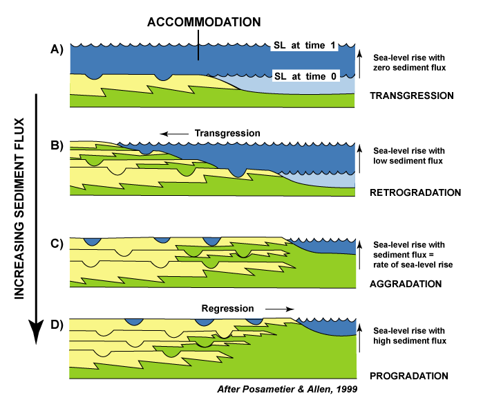
Theoretically the trajectory of the shoreline located on the margin of a basin that deepens offshore should track the response of sedimentary fill to the movement of relative sea level. Thus during a sea level fall of the falling (or early) lowstand system tract (FSST) the shoreline trajectory will be expected to fall offshore during a forced regression; then it may either aggrade or onlap landward, rising above the underlying sedimentary fill during the following lowstand (or late lowstand) system tract (LST). If the margin or basin floor are shallow enough, the shoreline trajectory will often build out at an initially shallow angle but as the sea level rise outstrips sediment supply the shoreline will retreat, climbing back over the underlying sedimentary fill. During the following transgression, a transgressive system tract forms and the shoreline will often be retrogradatonal in character, climbing and building back over the underlying sedimentary fill. During the following relative sea level highstand, if the basin margin is shallow enough then the trajectory of the shoreline will tend to prograde out at a low angle. Should the basin deepen rapidly then the trajectories of the shoreline will tend to steepen, being unable to fill the basin and build out over it. These general rules apply to both clastic and carbonate depositional systems, with the exception that when carbonates have become cemented penecontemporaneously at deposition they can maintain very steep margin trajectories, and, as in the modern Bahamas, may form cliffed margins in a submarine setting. Thus the trajectories of the shoreline range from those that build seaward either falling at high or low angles; project out horizontally or climb up at low, high angles or aggrade vertically. Trajectories can also move landward at low or high angles.
These patterns are well enough defined that the relationships between different shoreline trajectories, and facies in a basin are used to predict sedimentary facies along strike where different shoreline and shelf margin trajectories occur within the depositional basin. This rational is at the heart of using stacking patterns to establish which system tract is responsible for which geometric pattern and which facies may be expected up dip and down dip.
The thesis presented here is that the interpretation of shoreline trajectory conjointly with stacking patterns best involves the creation of three-dimensional models that simulate facies progradational, retrogradational and aggradational trajectory signals. The resulting geometries then show how these are a response to changes in the character of accommodation and varying rates of sediment accumulation.
In order to build these models a sequence stratigraphic analysis must be conducted in which the emphasis is placed on subdividing the section with correlatable surfaces and the interpretation of the relationship of these surfaces to high frequency changes in rates of sediment accumulation, tectonics and eustasy. Such interpretations use Walther's Law (a vertical progression of facies match corresponding lateral facies changes) and the recognition of system tract facies (Van Wagoner, et al, 1988 paradigm that assumes that genetically associated stratigraphic units were deposited during specific phases of the relative sea-level cycle). The resulting packages of facies are then represented as a conceptual model assemblage of three-dimensional facies. These are built by backstripping the various sequence stratigraphic surfaces and the sedimentary fill bracketed by them through time. These are then linked as a movie and run forward, creating the conceptual empirical model of the depositional history. As the movie is run the variations in the rates of change of the input parameters are examined to determine how the model would change if they were to change. Since at least three variables are involved in the development of the sedimentary geometries (namely sea level change, tectonic movement and rates of sediment accumulation) the models should be tested at least with an over simple empirical simulation. SEDPAK is one such simulator and its output is a means of constraining too fanciful a conceptual model. The major difference in this approach to that of many other sequence stratigraphers, is the combination of both sedimentary simulations tied to a free form conceptual model. While the scientific method encourages the scientist to gather data, form a hypothesis and test this with further observation, it should be recognized that only some of the data available is relevant and essential to determining the depositional setting of these rocks and their distribution. The approach outlined above enables one to filter the noise from the data, look for criteria that are considered essential to solving the problem at hand, test the geological model, and check to see if the data matches that expected for the conceptual model generated.
References
Borer, J.M., & Harris, P.M., 1995, Computer simulation of the Yates formation (Permian, Delaware basin) — sequence stratigraphy and shelf-to-basin correlation implications, in Martin, R.L., ed., In Search of New Permian basin Oil and Gas Fields: Using Today's Technologies and Tomorrow's Ideas for Exploration, Development, and 3D Seismic in a Matrue basin: Midland, TX, Permian basin Section-SEPM Publication 95-98, p. 111-132.
Eberli, Gregor P., Christopher G. St. C. Kendall, Phil Moore, Gregory L. Whittle, & Robert Cannon, 1994; Testing a Seismic Interpretation of Great Bahama Bank with a Computer Simulation, AAPG Bulletin, V. 78, No. 6, p. 981-1004.
Helland-Hansen, W., and Martinsen, O.J., 1996, shoreline trajectories and sequences: description of variable depositional-dip scenarios, Journal of Sedimentary Research 66 (4), 670–688.
Hunt, D., Kosa, E., Roberts, G.P., & Bockel-Rebelle, M.-O., 2000, Synsedimentary deformation and development of the Permian Capitan reef carbonate platform, Slaughter Canyon, Guadalupe Mountains, New Mexico [abs.], in Ahr, W.M., Harris, P.M., Morgan, W.A., Somerville, I.D., and Stanton, R.J., Jr., eds., Permo-Carboniferous carbonate Platforms and Reefs — SEPM-IAS Research and Field Conference, Programs and Abstracts Volume: Tulsa, OK, SEPM (Society for Sedimentary Geology), p. 81-82.
Kendall, C. G.St.C., Strobel, J., Tang, J., Moore, P., Cannon, R., Bezdek, J., & Biswas, G., 1989, Simulation of the Capitan shelf margin (Late Permian, Guadalupian) of west Texas/New Mexico, a response to eustatic change and an example of the use of SEDPAK, in Harris, P.M., and Grover, G.A., eds., Subsurface and Outcrop Examination of the Capitan Shelf Margin, Northern Delaware basin: Tulsa, OK, SEPM Core Workshop No. 13, p. 423-426.
Kendall, Christopher G. St. C., Abdulrahman. S. Alsharhan, Kurt Johnston & Sean R. Ryan; 2000, Can The Sedimentary Record Be Dated From A Sea-Level Chart? Examples from the Aptian of the UAE and Alaska, In A. S. Alsharhan and R. W. Scott, Eds, Society of Economic Petrologists and Mineralogists (SEPM) Special Publication 69 on the Jurassic/Cretaceous Platform-basin Systems; Middle East Models; p 65-76.
Kerans, C., And Fitchen, W.M., 1995, sequence hierarchy and facies architectures of a carbonate-ramp system: San Andres formation of Algerita Escarpment and western Guadalupe Mountains, west Texas and New Mexico, University of Texas, Bureau of Economic Geology Report of Investigations No. 235, 86 p.
Pomar, Louis, 1993, High Resolution sequence stratigraphy in Prograding Miocene carbonates: Application in seismic interpretation, In R.G. Loucks and J.F. Sarg, eds., carbonate sequence stratigraphy, Recent Developments and Applications, AAPG Memoir 57, p389-407
Steel, R., Gjelberg, J., Helland-Hansen, W., Kleinspehn, K., Nottved, A., & Rye-Larsen, M., 1985, The Tertiary strike-slip basins and orogenic belt of Spitsbergen; Biddle, Kevin T. (editor) Christie-Blick, Nicholas (editor), Strike-slip deformation, basin formation, and sedimentation, Special Publication - Society of Economic Paleontologists and Mineralogists, 37, p. 339-359, illus. incl. sects., sketch maps, 40 refs.
Van Wagoner, J.C., Mitchum, R.M., Campion, K.M., And Rahmanian, V.D. 1990, Siliciclastic sequence stratigraphy in Well Logs, Cores, and Outcrops. American Association of Petroleum Geologists, Tulsa, 55p .
Van Wagoner, J.C., H.W. Posamentier, R.M.Mitchum, P.R. Vaill , J.F. Sarg, T.S. Loutit & J. Hardenbal, 1988, An overview of the fundaformmentals of sequence stratigraphy and key definitions: In Wilgus, C.K., Hastings, B. S., Kendall, C. G. St. C., Posamentier, H. W., Ross, C. A., and Van Wagoner,J.C., eds., Sea-Level Changes - an Integrated Approach, SEPM Special Publication 42, p.39-45. |