The sequencestratigraphy of Lower Cretaceous strata of the Northeastern National Petroleum Reserve of Alaska (NPRA): A Test Case for age-dating sediments with sea level curves.
Abstract
A sequence stratigraphic framework for the Cretaceous sediments of the northeastern National Petroleum Reserve of Alaska (NPRA) was established using a public domain data set obtained from the United States Geological Survey (USGS), nearly 200 2-D seismic lines and 29 geophysical well logs, and Seismic Micro-Technology Inc.'s (SMT) Kingdom Suite software. This data set provided an excellent opportunity to test the validity of age-dating sedimentary sequences using the sea level curve developed by Haq and others.
| The study area was relatively tectonically stable during the Cretaceous, with a slow and constant rate of subsidence, and a relatively steady flux of clastic sediments into the Colville basin. Subsequent to establishing a sequence stratigraphic framework for the area, numerous and detailed chronostratigraphic charts were created to separate and analyze the changes in base level responsible for the sequences, relating them to delta migration, local tectonics and any eustatic signal preserved in the rock record. An overall second and third order eustatic signal appeared evident in the Cretaceous section but some have the higher-frequency (4th order?) sequences identified but these appear to be more localized and therefore may be related to delta migration. Based on our initial observations, it seems likely that the sea level curve developed by Haq, et al, could be successfully used to preliminarily date some of these sequences. |
 |
Objectives
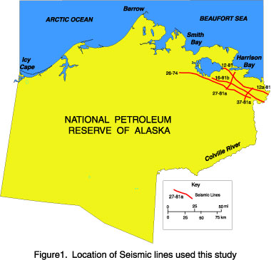
The sequence stratigraphy of the Lower Cretaceous of the NPRA is still not fully understood. The objective of this study was to investigate the control of deposition and delineate architecture of the Lower Cretaceous clinoforms within the northeastern part of the National Petroleum Reserve of Alaska (NPRA). Five regional seismic lines of the R8 USGS seismic survey were used in this study.
 |
Cross Section of Study Area
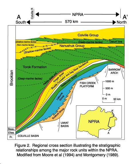
The geological cross section of the NPRA shows to the south the Lower Cretaceous sedimentary fill of the Foreland basin has subsided some 6000 meters while to the north in the vicinity of the Barrow Arch it has subsided no more than 2000 meters. The area was relatively tectonically stable during the Cretaceous, with a slow and constant rate of subsidence, and a relatively steady flux of clastic sediments into the Colville Basin.
|
Chronostratigraphy of Torok Formation and Nanushuk Group
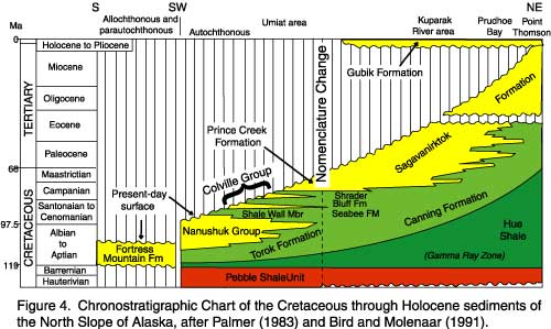
This Chronostratigraphic chart of the Lower Cretaceous sedimentary fill of the NPRA shows how the Nanushuk Group and Torok Formation were mapped as lithostratigraphic units which trangressed time while they accumulated through the Aptian and the Cenomanian. |
 |
 |
The Stratigraphic Problem
The age-dating of the Lower Cretaceous sedimentary fill of the NPRA is based on a public domain biostratigraphic data provided by the USGS. The data set is limited and provides poor biostratigraphic control for the area.
The seismic data used in this study shows that the Nanushuk Group (shallow deltaic and fluvial facies) and Torok Formation (delta slope and basin floor fan facies) is formed by a series of distinct north eastward prograding clinoforms. Many of these clinoforms have truncated crests that suggest erosion by changes in base level. Our hypothesis is that these clinoforms provide an excellent opportunity to test the validity of age-dating of sedimentary sequences using the sea level curve developed by Haq and others (1987). Our contention is that the northern flank of the basin (Barrow Arc) was relatively tectonically stable during the Cretaceous, with a slow and constant rate of subsidence, and a relatively steady influx of clastic sediments into the Colville Basin. The intent of this study was to establish a sequence stratigraphic framework for the area, producing detailed chronostratigraphic charts to separate and analyze the changes in base level controlling the geometries and distribution of the sequences. The erosional events on the seismic sections and chronostratigraphic were compared to the changes in base level predicted by the sea level curve developed by Haq, and others (1987) to establish their relative timing.
eustatic History of Lower Cretaceous
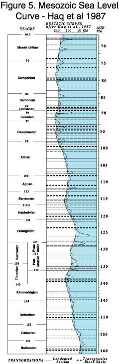
Biostratigraphic data for the Lower Cretaceous sedimentary fill of the NPRA suggest that the Nanushuk Group and Torok Formation accumulated through the Aptian and the Cenomanian. The sea level chart indicates that there were nine major changes in sea level over this time period, at least three of which might be expected to produce major second order type 1 unconformities.
|
|
Nanushuk & Torok Sedimentary Fill
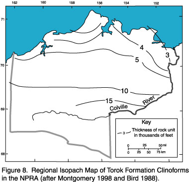
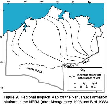
The Lower Cretaceous sedimentary fill Nanushuk Group and Torok formation are thickest in the Foreland and thin towards the north.
|
 |
|
|
The Lower Cretaceous sedimentary fill of the upper part of the Nanushuk Group and Torok Formation thin towards the east. |
Solution to the analysis of the exercise lines
Seismic Sequence Analysis Exercise Three Class Solution